Used by thousands of engineers, scientists and metrologists worldwide, MountainsMap® software is the gold standard in 2D and 3D surface texture analysis and metrology for use with profilometers and other surface measuring instruments.
Visualize, correct and analyze profiles and surfaces - Filter roughness & waviness according to ISO 16610 - Calculate ISO profile and areal parameters - Extract functional and metrological information from your data using advanced tools: Fourier analysis, particle analysis, step height, form fitting, wavelet filters, fractal analysis etc.
News, events, promotions, webinars
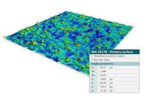
Roughness and ISO parameters
Separate roughness and waviness components of surfaces using the latest ISO 16610 advanced filtering techniques.
Access ISO parameters including:
- 3D parameters defined in ISO 25178 including height (Sa, Sq, Ssk, Sku, Sz, etc.,) and functional (Smr, Smc, Sxp) parameters.
- ISO 4287 (and upcoming ISO 21290) primary and roughness parameters (Ra, Rq, Rsk, Rmr, Rdc, Rdq, RPc, etc.).
Calculate & display ASME B46.1 2D and 3D parameters (USA), GB/T (China), DIN (Germany), JIS (Japan), NF (France), BSI (UK), UNE (Spain) and UNI (Italy) etc.
Perform functional analysis:
- Abbott-Firestone bearing ratio curve and depth distribution histogram.
- Subtraction of one surface from another (wear).
- Calculation of the material/void volume ratio and thickness of up to three vertical slices of a surface.
Data correction
- Normalize surfaces and remove artifacts prior to analysis. Tools include:
- Leveling.
- Flipping in the horizontal or vertical axis.
- Rotation in one-degree increments.
- Zone extraction.
- Correction or removal of anomalous scan lines.
- Thresholding to remove spikes.
- Retouching of isolated artifacts
- Deconvolution to minimize tip impact on the measurement data.
- Filling in missing data points.
- Surface smoothing.
- Resampling to increase image resolution.
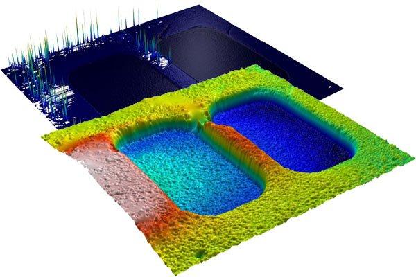
Surface Geometry
Perform fast and accurate analysis of surface geometry with tools for measuring:
- Distances.
- Angles.
- Areas of peaks and valleys.
- Volumes of bumps and holes.
- Step heights on surfaces and profiles.
- Coplanarity.
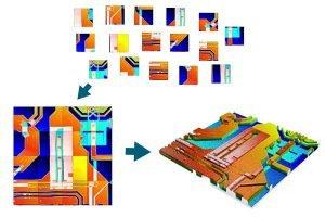
Surface stitching
- Automatically stitch together multiple measurements that overlap on the horizontal plane, to increase the field of view.
- Interactively patch two or more surface measurements at different heights into a single surface ready for analysis, to increase vertical range.
Sub-surface analysis
- Extract a rectangular or non-rectangular zone.
- Remove a slice from a surface by thresholding.
- Automatically partition a surface into motifs (texture cells), then use the Partition and Level operator to extract a sub-surface and level it.
Once a sub-surface or region of interest has been extracted it can be analyzed in exactly the same way as a full surface – parameters are calculated on the sub-surface only. This makes it possible, for example, to study the roughness, flatness and coplanarity of planes on MEMS and mechanical and electronic components.
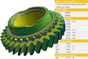
Shell (freeform surface) analysis
Shell visualization and analysis:
- Load, visualize and analyze freeform surfaces (shells) including STL, OBJ, PLY & 3MF files
- Analyze data produced by profilers with multiple scan axes
- Useful for applications where you need to see data from all angles (additive manufacturing, scans using X-ray tomography etc.)
- Extract an area of a shell and analyze it separately
- Extract surfaces and parametric profiles from shells
Perform metrological analysis on shells:
- Visualize surface curvature and deviation as colors in 3D
- Fit a reference form (plan, cylinder, sphere)
- Apply Gaussian-like filtering to calculate a smooth reference surface
- Calculate freeform surface texture parameters : height parameters, hybrid/spatial parameters, volume parameters
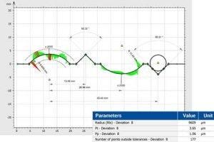
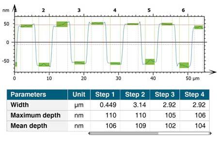
Advanced contour analysis
- Extract a vertical (x,z) or horizontal (x,y) contour (profile) from a surface.
- Define nominal form using straightforward interactive tools to associate geometric elements with contours
- Calculate dimensions (including distances, radii, diameters and angles) using autodimensioning and interactive tools
- Compare measured contours with CAD data (DXF) or user-defined nominal form
- Specify tolerances including large positional tolerances if required
- Visualize form deviations easily with magnified graphics
- Automatically generate a table of results including pass/fail status
- Gothic arch analysis of bearings
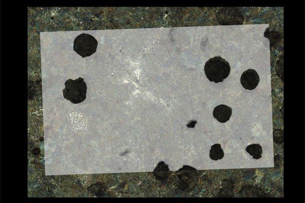
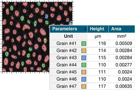
Particle analysis and more
Particle analysis:
- Automatically detect and count grains, particles, islands, bumps, holes and motifs (texture cells) using multiple detection methods
- Sort particles into groups using several criteria
- Visualize classes graphically in real-time, create control charts, histograms, scatter plots etc
Fourier & wavelets analysis
- Frequency analysis – interactive frequency spectrum, interactive power spectrum density, autocorrelation and intercorrelation
- Calculate isotropy, directionality and periodicity – view dominant surface directions on a compass rose and calculate parameters
- Denoise surfaces using the FFT plot editor
- Discrete wavelet filtering (3D surfaces and 2D profiles) – visualize a surface or profile at multiple scale levels – select roughness and waviness scale levels
- Continuous wavelet decomposition – study scale levels and spatial locations where phenomena occur
4D analysis
- Combine a series of surfaces or converted images for 4D analysis with respect to time, temperature, magnetic field or another dimension
- Visualize surface, profile and point evolution, fly over a surface as it changes and record a movie for presentations
- Generate statistics on surface texture parameter evolution
- Filter out noise and highlight areas with different kinetic behavior using the Karhunen-Loève transform (principal component analysis)
Correlative analysis
- Colocalize 3D surface topography data and images from different instruments (SEM, AFM etc.) to highlight surface features
- Overlay images on 3D topography (z axis in height units) or on pseudo-3D images (z axis in intensity units)
- Access a wide range of rendering options and set overlay transparency levels
Surface imaging & metrology expertise
- 30+ years' experience developing analysis software for the global industrial and scientific community
- Digital Surf specializes in surface texture analysis according to ISO standards (as used for profilometers)
- Heavy investment in research and development
- Our team of experts constantly test and improve the quality of Mountains® and ensure the software is compliant with current scientific norms and methods
Total traceability
- MountainsMap® unique analyis workflow lets users see all the analysis steps already applied to data
- Revert back to any step in the process at any time
- Workflow is interactive
Powerful automation
- Automate your repetitive work and speed up your analysis process
- Save analysis sequences and reapply automatically to large batches of data
- Accelerate analysis with built-in statistic tools
Scientific software with a document layout
- Organize the different steps of your surface analysis on one or several pages
- Publish these directly in different formats (PDF, Word and Excel) to share with your colleagues, students, clients, etc...
Works with all profilometers, trusted by the manufacturers
- Process data from any type of profilometer
- Join over 20,000+ Mountains® users worldwide
- Use surface analysis software chosen and provided by the leading manufacturers
- The majority of national research laboratories trust the precision of Mountains® (NIST, NPL, PTB, LNE, etc...)
Work and get help in your own language
- Work in one of the 11 languages available in the MountainsMap® user interface
- Get help on using the software for your applications from our international support team