Trusted by the world's greatest SEM manufacturers, MountainsSEM® software is a comprehensive, dedicated solution for your scanning electron microscope image analysis.
Add color to objects in SEM images in just a few clicks - Reconstruct the 3D topography of your sample from one or multiple image scans - Create 3D effects with EDS/EDX maps - Visualize & analyze FIB-SEM tomography cubes - Perform 2D particle analysis - Measure objects in SEM images (lengths, areas, angles, volumes etc.) - Combine SEM images with data from other instruments for correlative study - Stitch images for large specimens - Correct and enhance SEM images - Characterize surface roughness
News, events, promotions, webinars
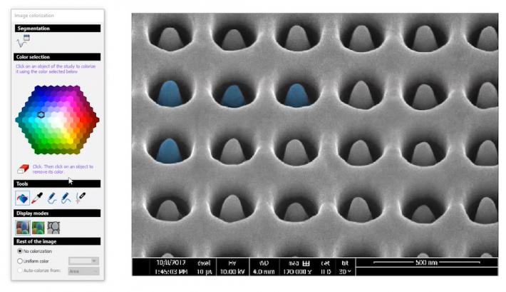
SEM image colorization & enhancement
Colorize SEM images easily:
- Go from black and white to color in just a few clicks
- Objects are detected automatically and colorized by the software
- No need to create layers or play with transparency
Learn more: www.digitalsurf.com/news/add-color-to-sem-images-in-only-a-few-steps/
Correct and enhance SEM images:
- smooth
- remove artefacts
- fix lighting
- adjust brightness and contrast
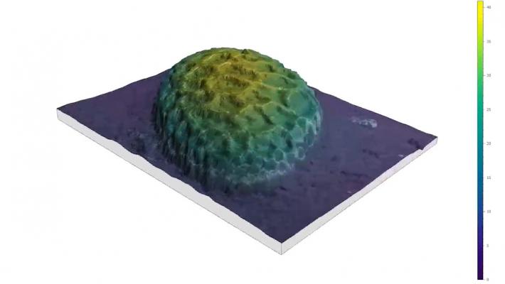
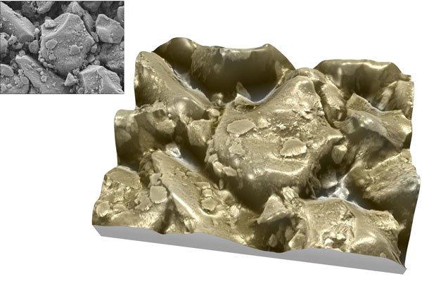
3D reconstruction from stereo pairs
- Switch from standard 2D images to “topographic” models
- Reconstruct a 3D model from two successive tilted scans of your sample in just a few seconds
- Obtain accurate height values from good quality stereo pairs
Learn more: www.digitalsurf.com/blog/7-tips-for-producing-sem-stereo-pairs/
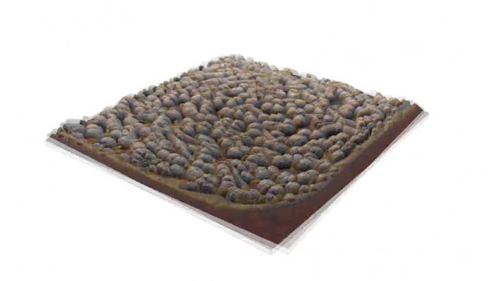
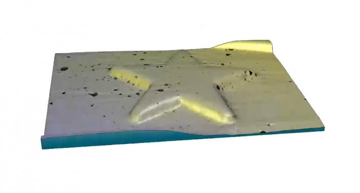
3D reconstruction from 4 images
- Upgrade your SEM images to 3D in seconds
- Generate a 3D model from 4 images obtained using a four-quadrant detector and visualize otherwise invisible details
- Achieve enhanced rendering by overlaying the combined SEM image on the 3D topography at a user-defined transparency level
Learn more: www.digitalsurf.com/blog/using-a-four-quadrant-detector-in-3d-reconstruction/
3D rendering from single images
- Generate rough-draft 3D renderings from single SEM images
- Improve visual interpretation of the image (contrary to 3D reconstruction from stereo pairs, height values are not metrological in this case).
Create "3D" effects with EDS/EDX maps
- Build spectacular renderings associating EDS (EDX) maps or other spectral/compositional data with SEM images (or topography if available)
- Highlight surface properties & composition
- Access a wide range of rendering options (palettes, color mixing, transparency etc.)
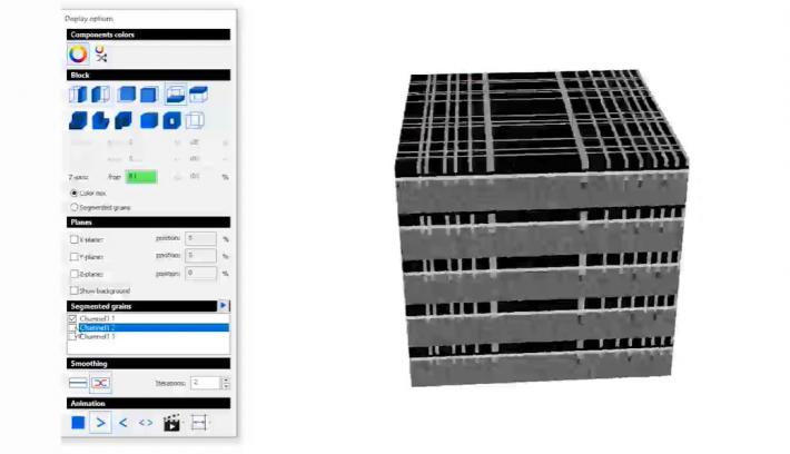
FIB-SEM tomography
- Load, display and analyze focused ion beam scanning electron microscopy image series as 3D voxel cubes
- Associate tomography and chemical analysis
- Slice through the inside of your materials: choose segmentation and animation settings
- Produce 3D particle and grains statistics from your 3D voxel cubes
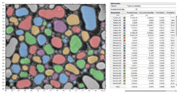
2D particle analysis
- Quickly identify and quantify features in virtually any SEM image
- Benefit from dedicated SEM-SE and SEM-BSE image segmentation & object detection
- Calculate over 70 different characteristics (area, perimeter, diameter etc.) and sort them into user-defined classes
- Generate statistics and create control charts, scatter plots, histograms etc.
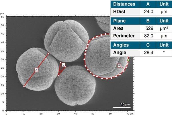
Scale & measure features
- Set images to scale
- Accurately measure any feature directly on the image itself: lengths, areas, perimeters, angles etc.
- Extract and measure profiles and horizontal contours (cross-sections).
Learn more: www.digitalsurf.com/news/measure-any-object-in-a-microscope-image/
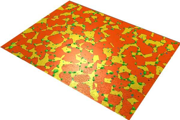
Correlative analysis
- Combine SEM images from different detectors (SE + BSE) or with data from other measurement instruments (AFM/SPMs, 3D optical microscopes) for correlative analysis
- Colocalize your SEM images with spectral analysis data (EDX, Cathodoluminescence…) and build impressive chemical maps
Works with all SEMs, trusted by the manufacturers
- Process data from any brand of SEM
- Join over 20,000+ Mountains® users worldwide
- Use image analysis software chosen and provided by the leading manufacturers
- The majority of national research laboratories trust the precision of Mountains® (NIST, NPL, PTB, LNE, etc...)
Scientific software with a document layout
- Organize the different steps of your SEM image processing (original images, distance measurements, particle statistics, etc...) on one or several pages
- Publish these directly in different formats (PDF, Word and Excel) to share with your colleagues, students, clients, etc...
Total traceability
- MountainsSEM® unique analyis workflow lets users see all the analysis steps already applied to data
- Revert back to any step in the process at any time
- Workflow is interactive
Powerful automation
- Automate your repetitive SEM work and speed up your analysis process
- Save analysis sequences and reapply automatically to large batches of data
- Accelerate analysis with built-in statistic tools
Surface imaging & metrology expertise
- 30+ years' experience developing analysis software for the global industrial and scientific community
- Digital Surf specializes in surface texture analysis according to ISO standards (as used for profilometers)
- Heavy investment in research and development
- Our team of experts constantly test and improve the quality of Mountains® and ensure the software is compliant with current scientific norms and methods
Work and get help in your own language
- Work in one of the 11 languages available in the MountainsMap® user interface
- Get help on using the software for your applications from our international support team